

A Pacific Coast Highway road trip from San Francisco to San Diego runs about 580 miles on Highway 1 and the US 101 stretches that join it. Big Sur is the part to plan around. In mid-November 2026, Caltrans listed one-way traffic control there and announced full daytime closures near Torre Canyon Bridge on November 18 and 19.
Published November 19, 2026.
I surf out of San Diego, so the southern end of this drive is the part I know from the driver’s seat. I write the route north to south for a reason covered below. My dogs come along on most coast drives, which means I read beach dog rules before I read restaurant menus. This guide covers the California coast only. A short note near the end explains how to add Oregon and Washington.
Pacific Coast Highway road trip: the legs side by side
Distances and times in the table come from OpenStreetMap-based OSRM routing. Waypoints sit on Highway 1 where it runs along the coast. They are no-stop, no-traffic figures, good for comparing legs and not for scheduling. The status column is what Caltrans published through November 15, 2026.
| Leg | Miles and drive time | Best stops | Best for | Status |
|---|---|---|---|---|
| San Francisco to Santa Cruz | About 82 miles, 2 hours | Half Moon Bay, Davenport | An easy first day, families | One-way traffic control at Davenport, Nov. 16 to 20. Lane reductions in Santa Cruz, Nov. 16 to 23. |
| Santa Cruz to Carmel | About 48 miles, 1 hour 5 minutes | Moss Landing, Monterey, Carmel Beach | Dog owners, beach walkers | Point Lobos State Natural Reserve listed as closed on Nov. 15. |
| Big Sur: Carmel to Ragged Point | About 78 miles, 2 hours | Bixby Creek Bridge, Pfeiffer Big Sur, McWay Falls overlook | First-timers, photographers | Work zones and two full daytime closures. Details below. |
| Ragged Point to Morro Bay | About 45 miles, 1 hour 10 minutes | San Simeon, Cambria | A quiet overnight | Tree-work traffic control near San Simeon and Cambria, Nov. 17 to 19. Lane closures for bridge replacement near Morro Bay through Dec. 31. |
| Morro Bay to Santa Barbara | About 107 miles, 2 hours 20 minutes | Pismo Beach, Santa Barbara waterfront | Covering ground fast | Check QuickMap. |
| Santa Barbara to Santa Monica, via Malibu | About 86 miles, 2 hours | Malibu beaches | Surfers, beach days | Check QuickMap. |
| Santa Monica to Laguna Beach | About 62 miles, 1 hour 50 minutes | Huntington Dog Beach, Laguna Beach | Dog owners, surfers | Check QuickMap. |
| Laguna Beach to San Diego | About 74 miles, 1 hour 40 minutes | Oceanside, La Jolla | A finish with swimming and tacos | Check QuickMap. |
My pick for the best leg is Big Sur, with no close second. The one I would shorten is the Los Angeles section between Santa Monica and Huntington Beach. It is city driving with a beach view now and then. I treat it as a transfer and save my daylight for the ends.
Is Highway 1 open through Big Sur right now?
As of mid-November 2026, yes, with work zones. Caltrans’ Big Sur emergency projects sheet, updated January 14, 2026, says all of Highway 1 is open. It lists Regent’s Slide, Paul’s Slide, Rocky Creek Viaduct, Dolan Point, Saint Francis and Shale Point as complete. The lane-closure data Caltrans District 5 published on November 15 shows no all-day closure on the Big Sur stretch. It does list the following.
- Torre Canyon Bridge, post mile 39.28 to 39.72: one-way traffic control for emergency work, daytime, November 16 to 18, 20 and 21.
- Torre Canyon Bridge, post mile 39 to 40: full closures that Caltrans announced for Wednesday, November 18 and Thursday, November 19, from 8 a.m. to noon and 1 p.m. to 5 p.m., weather permitting. The road is open from noon to 1 p.m.
- Post mile 29.7 to 31.17: one-way traffic control for drainage work, November 16 to 20, from 6:30 a.m. to about 7 p.m. (to 1 p.m. on Friday).
- Post mile 43.91 to 44.59: alternating lanes at a temporary signal for bridge work, listed November 6 to December 4.
- Post mile 54.0 to 54.96: one-way traffic at a temporary signal at a slide site, listed through December 31.
- Post mile 59.9 to 60.05: one-way traffic for bridge work, listed through November 30. Caltrans’ Rocky Creek project page puts its Rocky Creek site at post mile 60.0.
The Torre Canyon closures come from a November 6 Caltrans release. Crews are installing wire mesh on slopes above the road after the Timber Fire. They are also preparing for winter. The release asks drivers to avoid the area and allow extra time. It names no detour. On other days from November 16 to 20, the lists showed one-way control at several sites, so expect waits. A phone map shows the shortest line, not the wait at a signal. QuickMap is where to check the same morning.
This coast closes more than once a year. On August 27, Caltrans closed 40 miles from Gorda to north of Captain Cooper Elementary for the Timber and Plaskett fires. It told drivers to use US 101 as the alternate route. A September 2 release lifted the northern closure and kept the southern one. In February, a 6.8-mile segment near Regent’s Slide closed again when winter rain filled the catchment area with debris, per a February release. It gave no reopening estimate, and I will not guess one either.
One more notice matters for mid-November. A November 13 high surf advisory said Caltrans was ready to close Highway 1 near Monastery Beach if waves washed over the road. It listed Point Lobos and Garrapata Beach among beaches closed from Friday evening to Sunday morning. It called an extension through Tuesday very likely.
Big Sur stops, fees and what is closed
Big Sur is the reason to drive the whole thing. The road clings to cliffs above the Pacific, and every turn opens another view of the coast. Bixby Creek Bridge is the photo everyone knows. Pull off at the turnout, take your shot and move on. The miles after the bridge are better than the bridge. Best for: first-timers and anyone with a camera. Skip it if you are short on daylight or uneasy on cliff roads, and use US 101 inland instead.
Three state parks anchor the stretch. Each lists the same $10 vehicle day-use fee on its California State Parks page. Special rates can apply on busy days. Point Lobos is 3 miles south of Carmel and opens 8 a.m. to 5 p.m., last entry 4:30. The reserve showed as closed on November 15. Pfeiffer Big Sur is 26 miles south of Carmel. Its park page says it reopened October 16 after the Timber Fire. Pfeiffer Falls, Valley View and several other trails stay closed.
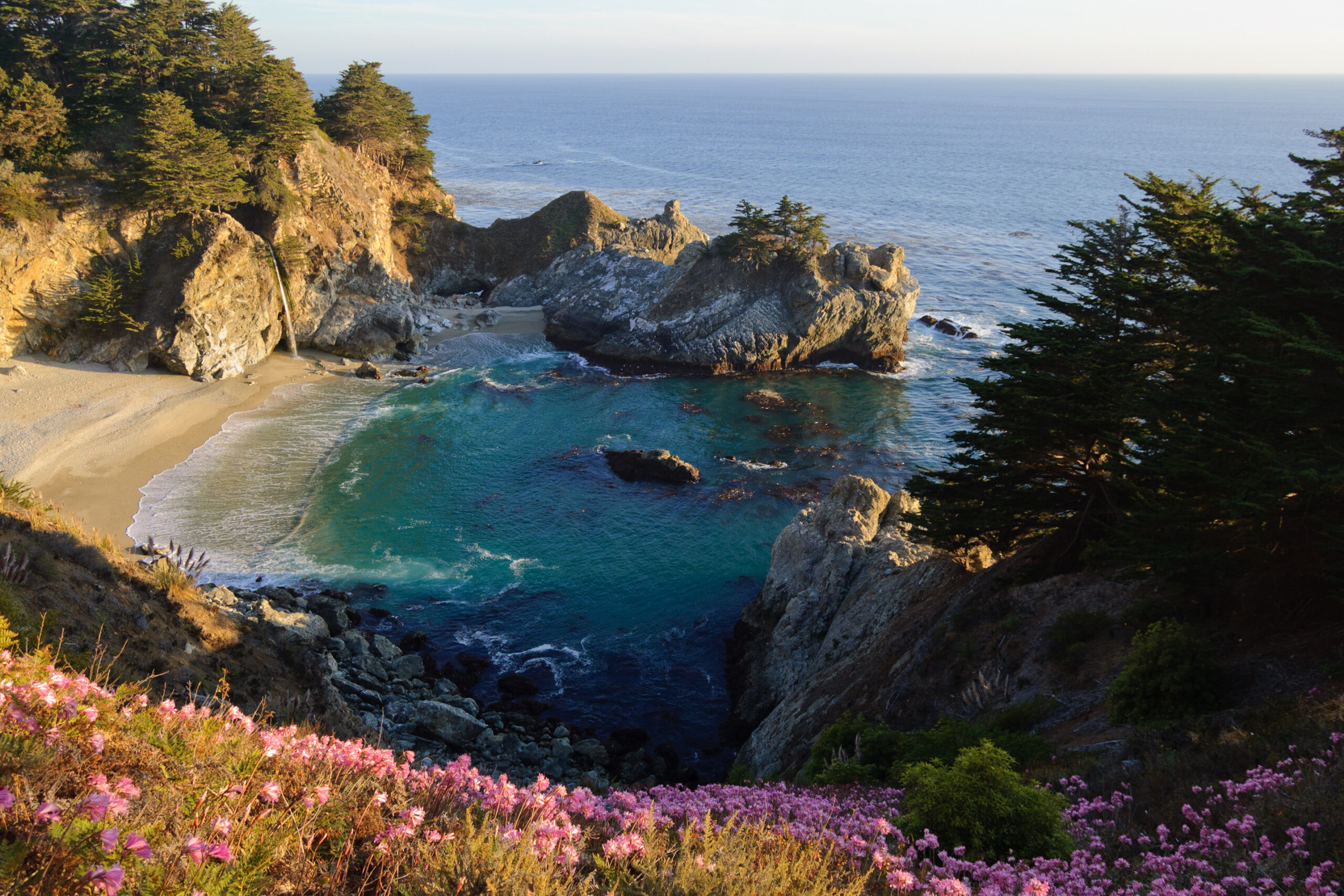
Julia Pfeiffer Burns State Park is 37 miles south of Carmel. It holds McWay Falls, an 80-foot waterfall that spills onto a beach. Its official page is blunt. There is no beach or ocean access at McWay Falls. Areas past the fences are off limits, with citation and arrest for trespassing. View it from the trail and stay behind the fence.
Which direction is best for the Pacific Coast Highway?
Go north to south. Driving south puts the ocean on your right. The lane next to the cliff edge is yours, and the pull-outs are on your side. Northbound drivers must cross traffic to reach most of them. On a road with few shoulders, that decides how often you can stop for photos without a knot in your stomach.
Skip it if you are starting from the south and cannot loop back. Then drive north and take the turnouts on the empty side of the road, with a clear view behind you. San Diego to San Francisco is the same road, just harder on the nerves.
Pacific Coast Highway road trip itinerary: 3, 5 or 10 days
Here is the planning tool I use. Cap each day at about 150 miles of routing, and cap Big Sur days at about 100. The leg distances above do the arithmetic for you. Three days cannot cover the whole coast, so do not try. The table shows where each trip length ends.
| Trip length | Day-by-day split | Ends in |
|---|---|---|
| 3 days | Day 1: San Francisco to Carmel (about 130 miles). Day 2: Carmel to Cambria (about 102 miles). Day 3: Cambria to Santa Barbara (about 128 miles). | Santa Barbara |
| 5 days | Day 1: San Francisco to Carmel. Day 2: Carmel to Cambria. Day 3: Cambria to Santa Barbara. Day 4: Santa Barbara to Santa Monica (about 86 miles). Day 5: Santa Monica to San Diego (about 136 miles). | San Diego |
| 10 days | Leave San Francisco on day 1. Sleep two nights in Santa Cruz or Monterey and two near Big Sur. Add one in Cambria, one in Santa Barbara, two in the Los Angeles area and one in Laguna Beach. Finish in San Diego on day 10. Most days stay under about 100 miles. | San Diego |
For a five-day trip, the Big Sur day is the one to protect. If Caltrans closes the road, you lose that day, not the whole drive. Build in a slack day if you have it. Put it at Carmel or Cambria, where you can wait out a closure with a roof and a meal. The five-day plan is best for most first trips. Skip the three-day plan if San Diego is the goal.
Fuel and charging on the Big Sur stretch
Treat Carmel to Cambria as one 102-mile jump, by the routing above. My rule: fill the tank in Carmel or Monterey, and do not drop below a quarter tank before Cambria. If you have ever watched a fuel gauge fall faster than the miles, you know why. Curves, stops and one-way waits burn more than flat highway does.
Electric drivers should arrive in Carmel full and pick the Cambria charger before leaving. A wait at a work zone is not the moment to learn how much range is left. Our guide to scenic road trips in Scotland flags the same fuel-gap problem on single-track roads.
Best time to drive the Pacific Coast Highway
In 2026, Caltrans shut parts of Big Sur for winter storm debris in February and for fire support in late August. That shapes my advice. I would pick late spring or early autumn, avoid the storm months, and watch the fire notices in summer. Any month needs a check of QuickMap within 48 hours of the drive.
Winter has a real upside: the beaches empty out. It also has big surf, as the November 13 notice shows, and a road that can close on short notice. If you want warm weather in the cold months without a closure gamble, see our warm winter vacations in the USA list.
Picks by traveler type
- First-timers: San Francisco to Carmel, then Big Sur, then Cambria. That is the famous part, and it fits in three days. Skip the south on a first trip if time is short.
- Surfers: Santa Cruz, Malibu and the Orange County beaches are where I would pull over. Check the lifeguard report before you paddle out. Skip Big Sur’s rocky coves for surfing.
- Families: San Francisco to Monterey and the Santa Barbara to Santa Monica run, where days are short and beaches are close to the road. Skip any day over 100 miles with young kids.
- Dog owners: Carmel Beach, Huntington Dog Beach and San Diego’s Dog Beach. Skip Point Lobos and McWay, which do not allow dogs.
Dog-friendly beaches along the Pacific Coast Highway
Two of the three Big Sur state parks above keep dogs out entirely, so lean on city beaches. Carmel’s beach rules page says dogs may be off leash on Carmel Beach if they stay under voice control. They must be leashed everywhere else in town. Bags are provided at the access points. Carmel Beach is best for dogs that come back when called. Skip it if your dog bolts, because the off-leash rule depends on voice control.
In Orange County, the City of Huntington Beach’s beach information page says dogs must be on a leash. They are allowed only on the service road and at Dog Beach. At the end of the road, the City of San Diego’s dog beach page lists two leash-free areas. One is Dog Beach, at the west end of the San Diego River Floodway. The other is Fiesta Island in Mission Bay.
Pfeiffer Big Sur is the one park worth a dog stop. Its park page allows dogs on the Warden’s Path and the River Path, and in day-use lots and the campground. Other trails are off limits to dogs. Never leave a dog in a parked car on this road.
Pacific Coast Highway from Oregon or Seattle to San Diego
People also search for Oregon to California and Seattle to San Diego. The coast keeps going north, with US 101 carrying most of the route through Oregon and Washington. I have kept this guide to California, because Big Sur and its closures need the space. If you add the north, start the California section where this guide starts. Drive it north to south.
If you can add an inland day, our Yosemite National Park travel guide covers the park.
Conditions, fees and closures change without notice. Confirm them on the Caltrans and California State Parks pages the day you drive.
Top photo: Bixby Creek Bridge on Highway 1 in Big Sur, by Diliff, CC BY-SA 3.0.
Frequently asked questions about a Pacific Coast Highway road trip
How many days do you need for the Pacific Coast Highway?
Five days is the shortest trip that reaches San Diego from San Francisco without rushing. I would add two more. At about 580 miles by the routing above, five days means roughly 120 miles a day. Pick three days only if you end in Santa Barbara.
Is Highway 1 closed in Big Sur?
As of mid-November 2026, Caltrans data lists work zones, not a long closure. It also lists the two full daytime closures announced for Torre Canyon Bridge on November 18 and 19. Closures change fast here, so check QuickMap the morning you drive and carry a plan B that uses US 101.
Should you drive the Pacific Coast Highway north or south?
South. The ocean-side lane is yours and the turnouts are on your side of the road. I would only go north if the trip ends in San Francisco.
Can you take a dog on the Pacific Coast Highway?
Yes, but plan around the rules. Carmel Beach, Huntington Dog Beach and San Diego’s Dog Beach all take dogs under their city rules. Point Lobos and McWay Falls do not. I would book dog-friendly rooms first, and sights second.
